LiDAR Operations
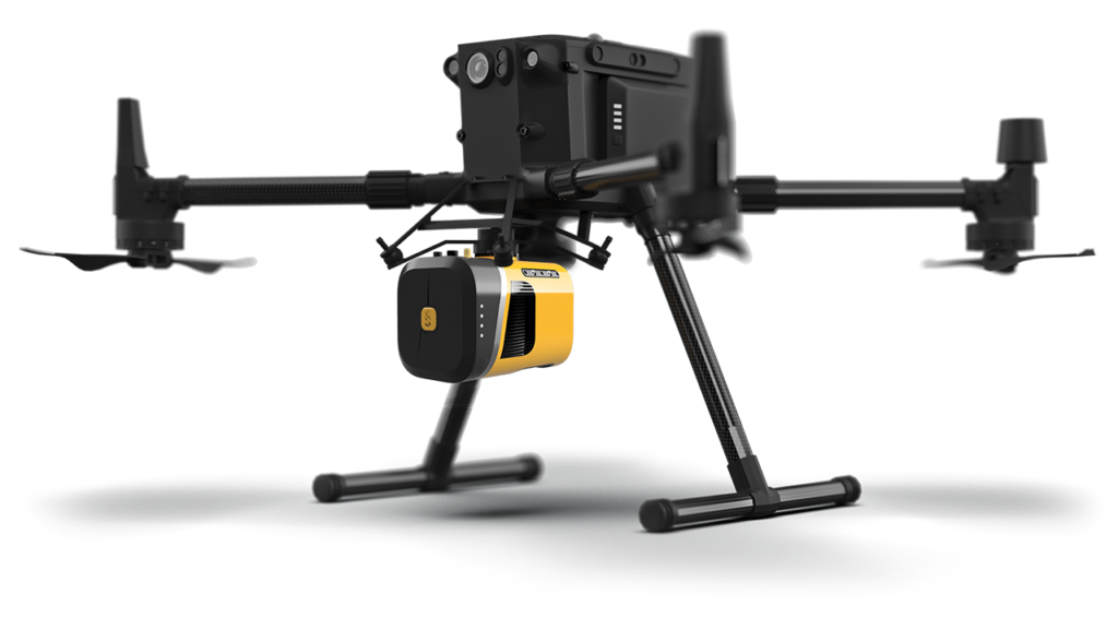 Landform’s Drone/LiDAR/Manned Aircraft Operations combine the latest, innovative, multispectral drone technology with top-notch industry software to produce the premium content and results our clients not only seek but demand.
Whether you need to enhance your marketing, survey grade topography, thermal sensing, 3D modelling, site comparison, or more, the Landform Operations (Drone/LiDAR/Manned Aircraft) team can significantly save your company time and money on your project.
What is LiDAR?
LiDAR is a remote sensing technology that uses laser pulses to measure distances to objects or surfaces. LiDAR systems consist of a laser scanner that emits laser pulses and a receiver that measures the time it takes for the pulses to bounce back after hitting objects or surfaces.
The Landform Aerial and Drone Operations team uses LiDAR for enhanced mapping and surveying applications. It can quickly and accurately measure the distances between objects or surfaces – creating a more comprehensive view of the environment for our client’s projects.
How does LiDAR work?
LiDAR works by emitting laser pulses from a scanner or sensor and then measuring the time it takes for those pulses to bounce back after hitting an object or surface. The basic steps in the LiDAR process are as follows:
- Emit laser pulses: A laser emits short pulses of light at a high frequency, typically 10,000 to 500,000 pulses per second.
- Measure the time it takes for the pulses to return: The laser pulses travel through the air until they encounter an object or surface, at which point they bounce back toward the LiDAR sensor. The LiDAR sensor measures the time it takes for the pulse to return, which allows it to calculate the distance between the sensor and the object or surface.
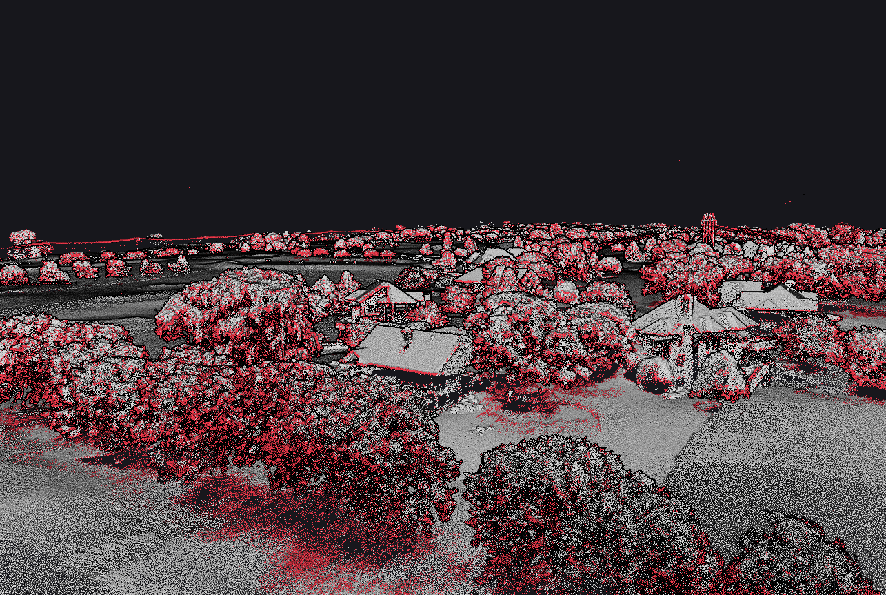
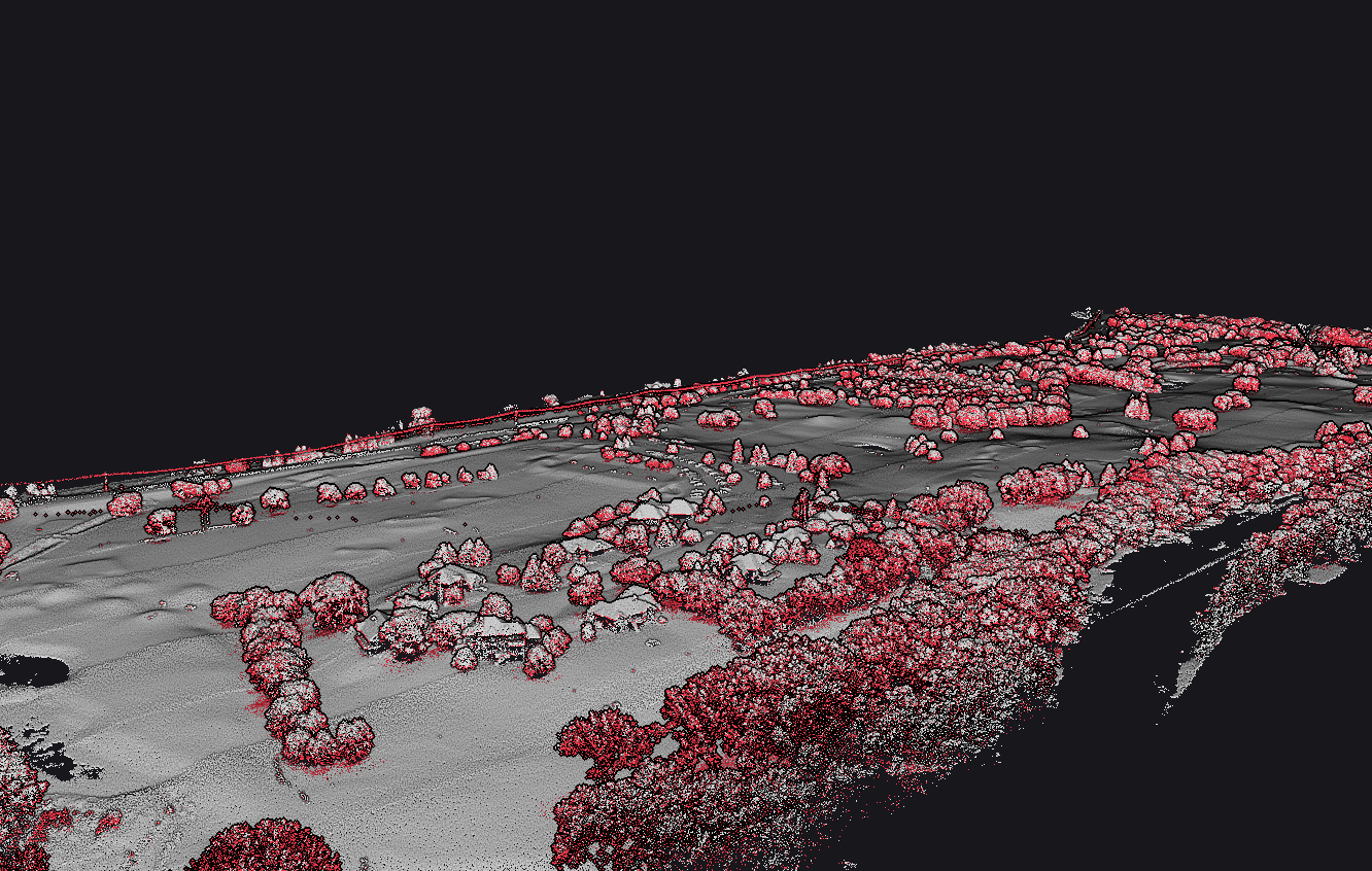
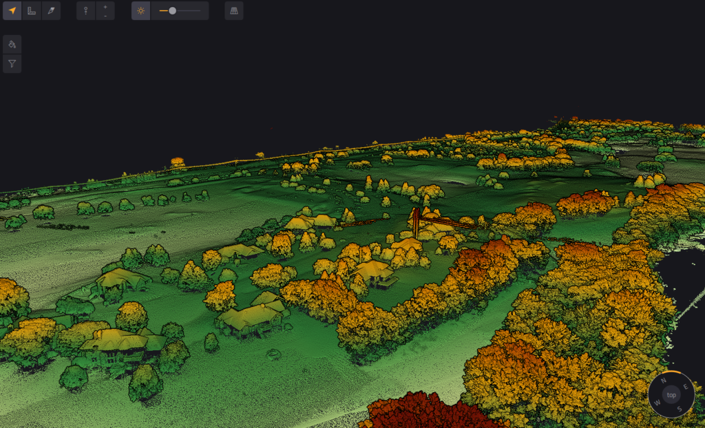
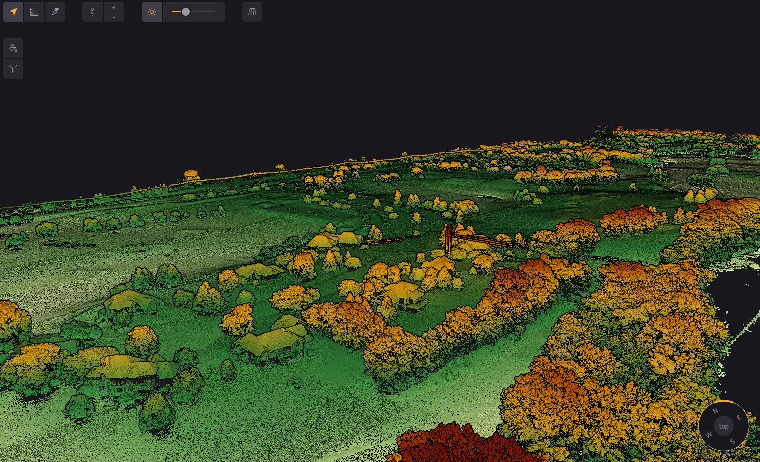
- Create a point cloud: As the LiDAR sensor emits and receives laser pulses, it generates a point cloud, a collection of millions of individual points representing the 3D location of objects and surfaces in the environment.
- Process the point cloud: The data can be processed using software to create a 3D model of the environment, which can be used for various applications, such as mapping, surveying, and autonomous navigation.
LiDAR sensors can be used in different ways, depending on the application. For example, airborne LiDAR sensors are mounted on aircraft or drones and are used for mapping large areas. In contrast, terrestrial LiDAR sensors are mounted on tripods or vehicles and are used for more localized applications, such as scanning buildings or archaeological sites.
How do we use LiDAR?
Depending on our client’s needs, the Landform Aerial Operations team uses LiDAR for various applications. Here are some simple use cases for LiDAR and how we can use them for our client’s projects:
- Mapping and surveying: LiDAR can create accurate, high-resolution maps of terrain, buildings, and other features. This can be useful for numerous industries, including urban planning, forestry, and agriculture.
- Construction and engineering: We use LiDAR for 3D models of terrain and site comparisons, and we create detailed 3D models of buildings, bridges, and other structures. This is extraordinarily useful for our clients, as it can help them visualize and plan projects more effectively.
Our team has industry-leading, professional expertise in LiDAR technology and can provide high-quality data and analysis for all of our client’s projects and needs.
Current LiDAR Projects

Understanding high-altitude & low-altitude LiDAR
High-altitude manned LiDAR and low-altitude unmanned LiDAR are two different approaches to LiDAR data collection, each with its own advantages.
High altitude, manned LiDAR:
- Operates from a fixed-wing aircraft or helicopter at an altitude of several thousand feet above ground level.
- Covers large areas quickly and efficiently, making it well-suited for mapping large-scale terrain or land use features.
- Can capture data at low point densities, producing relatively detailed 3D models within a meter accuracy.
- Requires a skilled pilot and experienced crew to operate, adding to the cost and complexity of data collection.
- May be limited by weather conditions, such as clouds or turbulence, which can impact data quality.
Low altitude, unmanned LiDAR:
- Operates from a drone at a lower altitude, typically below 400 feet above ground level.
- Offers greater flexibility and maneuverability than manned LiDAR, allowing for more detailed data collection in difficult-to-reach areas.
- Can be less expensive than manned LiDAR, as it requires less equipment and personnel.
- Can capture data at high point densities, producing highly detailed and accurate 3D models within a centimeter accuracy.
- Combines satellite, GPS, and a static ground station to deliver augmented data for your project.
- May not cover as much ground as manned LiDAR, making it better suited for site analysis and development.
In summary, high-altitude, manned LiDAR is best suited for large-scale projects that require high-density data collection. In contrast, low-altitude, unmanned LiDAR is ideal for projects or those that require more detailed data in hard-to-reach areas.

What are the advantages and benefits of using LiDAR?
There are several advantages and benefits to using LiDAR, including the following:
- Accurate and precise measurements: LiDAR increasingly provides highly accurate and precise measurements of distance, which can be important for applications such as surveying, mapping, and construction. LiDAR can measure distances with a precision of a few centimeters, which is much more accurate than other remote sensing technologies. This can lead to more precise and reliable data, which can help improve decision-making and reduce errors.
- Improved visualization and analysis: LiDAR can create highly detailed 3D images of objects and surfaces, which can be helpful in applications such as urban planning, construction, architecture, and archaeology. 3D imaging can provide a more comprehensive view of the environment and allow for better analysis and planning.
- Increased speed and efficiency: LiDAR can quickly scan large areas and generate high-resolution data in a short amount of time. LiDAR can also help improve efficiency for our client’s projects, where accurate and timely data is essential for decision-making.
-
Click to view image of cloud station no flight lines. Versatility: LiDAR can be used in various applications, including mapping, surveying, and construction. It can also be used in different environments, such as urban areas, forests, and oceans.
- Safety: LiDAR can be used to map and survey locations where traditional methods aren’t possible. It can also be used for safety inspections of infrastructure such as bridges and buildings, helping to ensure their structural integrity and prevent accidents.
Overall, the advantages and benefits of LiDAR provide our clients with more precise and accurate measurements, imaging, and detection capabilities.
Not sure which Aerial Operations service is right for you? Download our easy-to-understand comparison chart, or contact us today to review a case study.